The western fjord network of Norway represents one of the world's most dramatic glaciated maritime topographies. Formed through successive ice ages where immense glacier tongues carved U-shaped troughs below sea level, this landscape couples vertical basalt cliffs with sheltered waterways that extend hundreds of kilometres inland. Among the extensive network of Norwegian inlets, two waterways hold particular prominence under UNESCO World Heritage recognition: Geirangerfjord and Nærøyfjord.
Geirangerfjord: Landscape, Viewpoints and Access
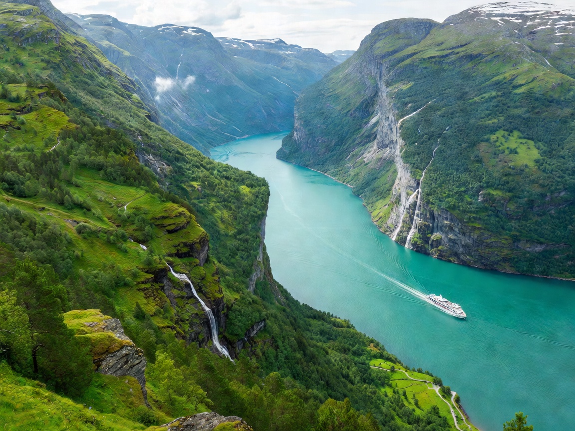
Geirangerfjord is a 15-kilometre-long branch of the larger Storfjorden system. The fjord is renowned for its precipitous rock walls that rise up to 1,400 metres above the surface, punctuated by cascading meltwater streams including De Syv Søstre (The Seven Sisters), Friaren (The Suitor), and Brudesløret (The Bridal Veil).
Logistical access to the village of Geiranger depends heavily on the season. During late spring through early autumn, vehicles approach via two mountain corridors: the Norwegian Scenic Route Geiranger–Trollstigen from the north via Valldal, or Highway 63 over the mountain pass from Grotli in the south. Key panoramic observation points include:
- Flydalsjuvet: Positioned approximately 4 kilometres south of Geiranger village, Flydalsjuvet provides a classic tiered platform vantage point over the inner harbour and cruise anchorages.
- Ørnesvingen (Eagle Road): Featuring eleven hairpin turns climbing toward Eidsdal, the highest bend features a cantilevered glass-and-steel viewing platform perched 620 metres above fjord level.
- Dalsnibba (Geiranger Skywalk): Accessible via a toll road from the mountain summit pass at Djupvatnet, this platform rises to 1,500 metres above sea level, offering views across both alpine snowfields and the fjord abyss below.
Flåm and the Nærøyfjord Corridor
Situated at the innermost terminus of Aurlandsfjord—an arm of the 204-kilometre Sognefjord—the village of Flåm serves as the primary intermodal junction connecting the national rail system with maritime fjord passenger vessels. Directly adjacent lies Nærøyfjord, renowned as one of the narrowest fjords in Europe, measuring just 250 metres wide at its tightest point between sheer 1,200-metre rock faces.
Environmental Maritime Regulations
In response to environmental protection legislation passed by the Norwegian Parliament, zero-emission regulations govern passenger vessels operating in World Heritage fjords. Travellers navigating between Flåm and Gudvangen frequently travel aboard battery-electric catamarans designed to eliminate combustion exhaust and underwater acoustic disruption within the enclosed valley ecosystem.
Transit Mode Comparison: Ferry vs. Road Travel
When structuring an itinerary across Western Norway, travellers must evaluate the functional differences between passenger ferries, car ferries, and tunnel-heavy roadway transit. The table below outlines primary operational distinctions.
| Transit Method | Scenic Quality | Travel Flexibility | Seasonal Availability |
|---|---|---|---|
| Electric Fjord Catamaran (Flåm–Gudvangen) | Panoramic waterline perspective of vertical falls; quiet electric propulsion. | Fixed passenger schedules; requires seat reservation in peak summer. | Year-round daily service between major transit hubs. |
| Car Ferry (Geiranger–Hellesylt) | Direct transit through the heart of Geirangerfjord; carries vehicles. | Vehicle space fills rapidly during July; higher transit fare. | May through October operational window. |
| Lærdal Tunnel & Road E16 | Subterranean transit; 24.5 km passage through solid mountain rock. | Continuous vehicle transit; bypasses weather-exposed passes. | Open year-round barring maintenance windows. |
| Aurlandsfjellet Snow Road (Fv243) | High alpine plateau crossing with the cantilevered Stegastein lookout. | Narrow single-lane passing bays; unsuitable for heavy vehicles. | Closed by snow from October until late May or early June. |
Pros and Cons of Staying in Valley Hubs
Advantages of Fjord Bases
Overnighting in Flåm, Aurland, or Geiranger grants early morning and late evening access to viewpoints once daytime tour excursions and cruise passenger volumes subside. Kayaking excursions, guided rib boat departures, and trailhead walks are accessible immediately from waterfront lodgings.
Logistical Constraints
Valley villages have strictly finite accommodation capacity. Grocery options and dining services are concentrated, and summer room rates rise steeply without advance planning. Fog and low cloud cover can periodically settle in the fjord floor, obscuring high mountain viewpoints.
Recommended Hiking Trails
For independent travellers seeking to explore beyond road lookouts, several marked Norwegian Trekking Association (DNT) routes provide direct valley ascents:
- Skageflå Cliff Farm (Geiranger): Reached either via a strenuous uphill trek from Homlong or by water-taxi drop-off at the cliff base followed by a steep 250-metre rock scramble using bolted cables. Skageflå offers direct views across to the Seven Sisters waterfall.
- Prest Hike (Aurland): Located along the ridge above Aurlandsfjord past the Stegastein platform, this 2.5-hour round-trip trail ascends to 1,363 metres, presenting unhindered aerial panoramas of Aurlandsfjord stretching toward Sognefjord.
- Rimstigen (Nærøyfjord): Departing from Bakka on the western shore of Nærøyfjord, this historic post trail climbs 725 vertical metres in approximately 2 kilometres, demanding strong physical stamina and ankle support on uneven rock stairways.
Practical Seasonality & Gear Recommendations
Weather along the western seaboard is heavily influenced by maritime Atlantic weather fronts. Rainfall is common throughout all twelve months, requiring layered clothing systems comprising a breathable merino wool base, an insulating mid-layer, and a seam-sealed waterproof hardshell jacket. Footwear must provide structured ankle support and vibram-style lugged soles capable of gripping wet schist and granite surfaces.